UPHESC Assistant Professor Geology · 100 questions

UPHESC Assistant Professor Geology PYQs

Real previous year questions, subject-wise. Try the question, then open the answer and the explanation in Hindi & English – free, no login.

Courses – airGurukul

70 questions in Geology / Earth Sciences.

Q61.
Crustal shortening takes place due to :
पटल के छोटे होने का कारण है :
  1. ANormal faultingसामान्य भ्रंशीकरण
  2. BFolding and thrustingवलनता और थ्रस्टिंग
  3. CStrike slip faultingनतिलम्ब – सर्पण भ्रंशीकरण
  4. DMetamorphismकायान्तरण
Show answer

Concept: Compression shortens and thickens the crust through folding and thrust (reverse) faulting, as in fold-and-thrust belts like the Himalaya.

  1. Normal faulting – crustal extension (lengthening).
  2. Strike-slip faulting – horizontal displacement with no net shortening.
  3. Metamorphism is a change in mineralogy/texture, not a shortening mechanism.

Short trick: Squeeze → folds + thrusts; Stretch → normal faults.

अवधारणा: संपीडन भूपर्पटी को वलन और क्षेप (थ्रस्ट) भ्रंशन द्वारा छोटा व मोटा करता है, जैसे हिमालय की वलन-क्षेप पट्टी।

  1. सामान्य भ्रंश – विस्तार (लंबाई बढ़ना)।
  2. नतिलम्ब-सर्पण भ्रंश – क्षैतिज विस्थापन, शुद्ध संकुचन नहीं।
  3. कायांतरण खनिज/गठन परिवर्तन है।

याद रखें: दबाव → वलन + थ्रस्ट; खिंचाव → सामान्य भ्रंश।
UPHESC Assistant Professor GeologyGeology / Earth SciencesCrustal shortening and extensionUPHESC Assistant Professor Geology · Booklet 1C78 (Series A)
Q62.
The ratio of lateral strain to longitudinal strain is known as -
पार्श्व विकृति एवं अनुदैर्ध्य विकृति के अनुपात को कहते हैं ।
  1. APoisson ratioप्वासों अनुपात
  2. BYoung's modulusटांग का गुणांक
  3. CBulk modulusआयतन प्रत्यास्थता गुणांक
  4. DModulus of rigidityप्रत्यास्थता गुणांक
Show answer

Concept: Poisson's ratio ν = lateral strain / longitudinal strain (dimensionless; about 0.25 for most rocks, 0.5 for incompressible fluids).

  1. Young's modulus E = longitudinal stress / longitudinal strain.
  2. Bulk modulus K = pressure / volumetric strain.
  3. Rigidity (shear) modulus G = shear stress / shear strain.

Short trick: Poisson = sideways ÷ lengthwise strain.

अवधारणा: प्वासों अनुपात ν = पार्श्व विकृति / अनुदैर्ध्य विकृति (विमाहीन; अधिकांश शैलों में ~0.25)।

  1. यंग गुणांक E = अनुदैर्ध्य प्रतिबल / अनुदैर्ध्य विकृति।
  2. आयतन गुणांक K = दाब / आयतन विकृति।
  3. दृढ़ता गुणांक G = अपरूपण प्रतिबल / अपरूपण विकृति।

याद रखें: प्वासों = पार्श्व ÷ अनुदैर्ध्य विकृति।

UPHESC Assistant Professor GeologyGeology / Earth SciencesElastic constantsUPHESC Assistant Professor Geology · Booklet 1C78 (Series A)
Q63.
Match the List-I and List-II and choose the correct answer from the code given below :
List-IList-II
(P) Initial stage(1) Alluvial fan
(Q) Youth stage(2) V shaped valley
(R) Mature stage(3) Pot holes
(S) Old stage(4) Flood plains
Codes :
सूची–I और सूची–II का मिलान कीजिए तथा नीचे दिये गये कोड से सही उत्तर दीजिए :
सूची–Iसूची–II
(P) आरंभिक चरण(1) जलोट पंखा
(Q) युवा चरण(2) V आकृति की घाटी
(R) परिपक्व चरण(3) पाट होल्स
(S) वृद्ध चरण(4) वाट के मैदान
कोड :
  1. A(P)-(1), (Q)-(2), (R)-(3), (S)-(4)
  2. B(P)-(2), (Q)-(1), (R)-(4), (S)-(3)
  3. C(P)-(4), (Q)-(3), (R)-(2), (S)-(1)
  4. D(P)-(3), (Q)-(2), (R)-(1), (S)-(4)
Show answer

Concept: Each stage of the fluvial cycle has typical landforms.

  1. Initial stage – vigorous down-cutting into bedrock by eddies with pebbles: pot holes → (3).
  2. Youth – deep V-shaped valleys, gorges → (2).
  3. Mature – where the river leaves the mountains onto the plains, its load spreads as alluvial fans → (1).
  4. Old stage – broad flood plains, meanders, ox-bow lakes → (4). Code 3-2-1-4.

Short trick: Pothole → V-valley → fan → flood plain (mountain to plain).

अवधारणा: नदी चक्र की प्रत्येक अवस्था के विशिष्ट स्थलरूप होते हैं।

  1. आरंभिक अवस्था – कंकड़-युक्त भँवरों से तल का तीव्र कटाव: जलगर्तिका (पॉट होल) → (3)।
  2. युवा – गहरी V-आकार घाटी, गॉर्ज → (2)।
  3. प्रौढ़ – पर्वत से मैदान में प्रवेश पर जलोढ़ पंख → (1)।
  4. वृद्ध – चौड़े बाढ़ मैदान, विसर्प, गोखुर झील → (4)। कोड 3-2-1-4।

याद रखें: पॉटहोल → V-घाटी → जलोढ़ पंख → बाढ़ मैदान।

UPHESC Assistant Professor GeologyGeology / Earth SciencesFluvial landforms and stages of a riverUPHESC Assistant Professor Geology · Booklet 1C78 (Series A)
Q64.
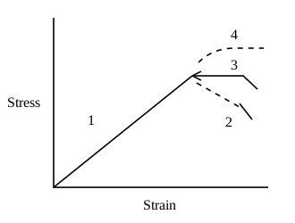
In the given stress - strain graph of rock, sector 2 represents :
किसी शैल के लिए गए प्रतिबल–विकृति ग्राफ में खण्ड 2 निरूपित करता है :
  1. AElastic deformationप्रत्यास्थ विरुपण
  2. BPlastic deformationसुघटय विरुपण
  3. CStrain hardeningविकृति दृढ़ीकरण
  4. DStrain softeningविकृति मृदुलन
Show answer

Concept: After the elastic straight line (1) and the yield point, the curve can follow three paths: horizontal (3) = ideal plastic flow, rising (4) = strain hardening (more stress needed for more strain), falling (2) = strain softening (stress needed drops as strain increases).

  1. Sector 2 slopes downward beyond yield – the rock weakens with continued strain → strain softening.
  2. Sector 1 – elastic; sector 3 – perfectly plastic; sector 4 – strain hardening.

Short trick: After yield: up = hardening, flat = plastic, down = softening.

अवधारणा: प्रत्यास्थ सीधी रेखा (1) व पराभव बिंदु के बाद वक्र तीन मार्ग ले सकता है: क्षैतिज (3) = आदर्श सुघट्य प्रवाह, ऊपर उठता (4) = विकृति दृढ़ीकरण, नीचे गिरता (2) = विकृति मृदुलन।

  1. खंड 2 पराभव के बाद नीचे झुकता है – विकृति बढ़ने पर शैल कमजोर होता है → विकृति मृदुलन।
  2. खंड 1 – प्रत्यास्थ; 3 – पूर्ण सुघट्य; 4 – विकृति दृढ़ीकरण।

याद रखें: पराभव के बाद: ऊपर = दृढ़ीकरण, सपाट = सुघट्य, नीचे = मृदुलन।

UPHESC Assistant Professor GeologyGeology / Earth SciencesStress–strain behaviour of rocksUPHESC Assistant Professor Geology · Booklet 1C78 (Series A)
Q65.
In northern hemisphere oceanic circulation happens :
उत्तरी हेमिस्फीयर में समुद्र का सरकुलेशन किस तरीके का होता है :
  1. AAnti clockwiseएन्टीक्लाकवाइज
  2. BClockwiseक्लाक वाइज
  3. CParallel to equatorइक्वेटर के समानन्तर
  4. DParallel to poleपोल के समानान्तर
Show answer

Concept: Driven by the trade winds and westerlies and deflected to the right by the Coriolis force, the major subtropical ocean gyres circulate clockwise in the Northern Hemisphere and anticlockwise in the Southern Hemisphere.

  1. N. Atlantic gyre: Gulf Stream → N. Atlantic Drift → Canary → N. Equatorial current (clockwise).
  2. N. Pacific: Kuroshio → N. Pacific → California → N. Equatorial (clockwise).

Short trick: North – Coriolis to the right – clockwise gyres.

अवधारणा: व्यापारिक पवनों व पछुआ पवनों से संचालित तथा कोरिऑलिस बल से दाईं ओर विक्षेपित होकर, उत्तरी गोलार्ध में प्रमुख उपोष्ण महासागरीय भँवर दक्षिणावर्त (क्लॉकवाइज़) और दक्षिणी गोलार्ध में वामावर्त घूमते हैं।

  1. उत्तरी अटलांटिक: गल्फ स्ट्रीम → उ. अटलांटिक ड्रिफ्ट → कैनरी → उ. विषुवतीय धारा।
  2. उत्तरी प्रशांत: क्यूरोशियो → उ. प्रशांत → कैलिफ़ोर्निया धारा।

याद रखें: उत्तर – कोरिऑलिस दाईं ओर – दक्षिणावर्त।

UPHESC Assistant Professor GeologyGeology / Earth SciencesOcean gyresUPHESC Assistant Professor Geology · Booklet 1C78 (Series A)
Q66.
The largest highest and most extensive reefs of all type of coral reefs :
सभी प्रकार की मूंगे की भितियों में विशालतम उच्चतम और सबसे लायक भिति है :
  1. ABarrier reefsवैरियर भितियाँ
  2. BAtollsप्रवाल द्वीप
  3. CFringing reefsसजावटी भितियाँ
  4. DLagoon reefsलैगून भितियाँ
Show answer

Concept: Barrier reefs, separated from the coast by a wide, deep lagoon, are the largest, highest and most extensive of all reef types; the Great Barrier Reef of Australia extends ~2300 km.

  1. Fringing reefs – narrow reefs attached to the shore; most common but small.
  2. Atolls – ring-shaped reefs around a lagoon, no central island (e.g. Lakshadweep).

Short trick: Great Barrier Reef = the biggest reef = barrier type.

अवधारणा: अवरोधक (बैरियर) भित्तियाँ, जो तट से चौड़े-गहरे लैगून द्वारा अलग होती हैं, सभी प्रकारों में सबसे बड़ी, ऊँची और विस्तृत होती हैं; ऑस्ट्रेलिया की ग्रेट बैरियर रीफ ~2300 किमी लंबी है।

  1. तटीय (फ्रिंजिंग) भित्ति – तट से जुड़ी संकरी भित्ति।
  2. एटॉल – लैगून को घेरती वलयाकार भित्ति (लक्षद्वीप)।

याद रखें: ग्रेट बैरियर रीफ = सबसे बड़ी = अवरोधक भित्ति।

UPHESC Assistant Professor GeologyGeology / Earth SciencesCoral reefsUPHESC Assistant Professor Geology · Booklet 1C78 (Series A)
Q67.
Thermohaline circulation is related to which of the following ?
थरमोहेलाइन परिसरचण निम्न में से किससे सम्बन्धित है ?
  1. ATemperature gradient in mantleमेन्टल के तापमान प्रवणता
  2. BSurface currents in oceanसमुद्र में सतहीय प्रवाह
  3. CDifference in salinity and temperature of oceanic waterसमुद्रीय जल की लवणता एवं तापमान के अन्तर
  4. DConvection currents in troposphereट्रोपोस्फीयर में कन्वेक्शन करेन्ट
Show answer

Concept: Thermohaline ('thermo' = heat, 'haline' = salt) circulation is the global deep-ocean 'conveyor belt' driven by density differences caused by temperature and salinity.

  1. Cold, salty water sinks in the North Atlantic and around Antarctica, flows along the deep ocean and upwells elsewhere.
  2. Surface currents are mainly wind-driven, not thermohaline.

Short trick: Thermo + haline = temperature + salt → density-driven deep currents.

अवधारणा: तापलवणीय (थर्मो = ताप, हेलाइन = लवण) परिसंचरण ताप व लवणता से उत्पन्न घनत्व-अंतर से चलने वाला वैश्विक गहन महासागरीय 'कन्वेयर बेल्ट' है।

  1. ठंडा, खारा जल उत्तरी अटलांटिक व अंटार्कटिका के पास डूबता है और गहराई में बहकर अन्यत्र ऊपर आता है।
  2. सतही धाराएँ मुख्यतः पवन-चालित हैं।

याद रखें: थर्मो + हेलाइन = ताप + लवण → घनत्व-चालित गहन धाराएँ।

UPHESC Assistant Professor GeologyGeology / Earth SciencesThermohaline circulationUPHESC Assistant Professor Geology · Booklet 1C78 (Series A)
Q68.
What is the rate of terrigenous sediment accumulation on the deep ocean floor ?
डीप समुद्र सतह पर टेरीजीनस सेडीमेंट संचय होने की दर क्या होती है ?
  1. A2 mm/year
  2. B2 mm/100 year
  3. C3.1 mm/year
  4. D2 mm/1000 year
Show answer

Concept: Fine terrigenous (wind- and current-borne) clay settles on the abyssal floor extremely slowly – of the order of 1–2 mm per 1000 years (pelagic red/brown clay).

  1. Biogenic oozes accumulate faster, ~1–3 cm/1000 yr.
  2. mm/year rates are typical of continental shelves, deltas and lakes – far too fast for the deep ocean.

Short trick: Deep-sea clay: about a millimetre per millennium.

अवधारणा: महीन स्थलजात (पवन व धारा-वाहित) क्ले गहन सागर तल पर अत्यंत धीरे जमती है – लगभग 1–2 मिमी प्रति 1000 वर्ष (पेलैजिक लाल/भूरी क्ले)।

  1. जैवजनित ऊज़ इससे तेज़, ~1–3 सेमी/1000 वर्ष।
  2. मिमी/वर्ष दर महाद्वीपीय शेल्फ, डेल्टा व झीलों की होती है।

याद रखें: गहन सागर क्ले: लगभग 1 मिमी प्रति सहस्राब्दी।

UPHESC Assistant Professor GeologyGeology / Earth SciencesDeep-sea sedimentation ratesUPHESC Assistant Professor Geology · Booklet 1C78 (Series A)
Q69.
Which ooze in the most common found on the ocean floor around the Antarctica ?
अंटार्कटिका के चारों तरफ समुद्र सतह पर कौन सा ऊज सामान्य तौर पर मिलता है :
  1. ARadiolarean oozeरेडियोलेरियन ऊज
  2. BDiatom oozeडाइएटम ऊज
  3. CCarbonate oozeकारबोनेट ऊज
  4. DAll of the aboveउपरोक्त सभी
Show answer

Concept: A broad belt of siliceous diatom ooze encircles Antarctica (Southern Ocean) and also occurs in the high-latitude North Pacific, where cold, nutrient-rich upwelling waters support diatom blooms.

  1. Radiolarian ooze – mainly the equatorial Pacific.
  2. Carbonate (Globigerina) ooze – warm, shallower (above CCD) floors of the Atlantic; carbonate dissolves in cold Antarctic waters.

Short trick: Diatoms – cold poles; Radiolaria – equator; Globigerina – warm, above CCD.

अवधारणा: अंटार्कटिका (दक्षिणी महासागर) के चारों ओर सिलिकामय डायटम ऊज़ की चौड़ी पट्टी है (उत्तरी प्रशांत के उच्च अक्षांशों में भी), जहाँ ठंडा, पोषक-समृद्ध उत्प्रवाह डायटम को बढ़ाता है।

  1. रेडियोलेरियन ऊज़ – मुख्यतः विषुवतीय प्रशांत।
  2. कार्बोनेट (ग्लोबिजेराइना) ऊज़ – गर्म, CCD से ऊपर के तल; ठंडे जल में कार्बोनेट घुल जाता है।

याद रखें: डायटम – ठंडे ध्रुव; रेडियोलेरिया – विषुवत; ग्लोबिजेराइना – गर्म।

UPHESC Assistant Professor GeologyGeology / Earth SciencesPelagic oozes – distributionUPHESC Assistant Professor Geology · Booklet 1C78 (Series A)
Q70.
In an area, where piezometric surface overlies the ground surface, which one of the following well types will result ?
किसी क्षेत्र में पीजोमेट्रीक तल यदि सतही तल के उपर पाया जाता है तो इनमें से किस तरह के वेल (कुंए well) पाये जायेगें ?
  1. AOrdinary wellसामान्य वेल (कुंए)
  2. BDry wellसुखे हुए कुंए
  3. CFlowing wellबहता हुआ वेल (कुंआ)
  4. DNone of theseइनमें से कोई नहीं
Show answer

Concept: In a confined aquifer, water in a well rises to the piezometric (potentiometric) surface; where this surface lies above ground level, water flows out at the surface without pumping – a flowing artesian well.

  1. If the piezometric surface is above the aquifer top but below ground → non-flowing artesian well.
  2. Classic example: Great Artesian Basin, Australia.

Short trick: Piezometric surface above ground = free-flowing artesian well.

अवधारणा: परिरुद्ध जलभृत में कुएँ का जल दाब-मितीय (पीज़ोमेट्रिक) तल तक उठता है; जहाँ यह तल भूमि सतह से ऊपर हो, वहाँ बिना पम्प के जल अपने आप बाहर बहता है – प्रवाही आर्टिज़ियन कुआँ।

  1. यदि पीज़ोमेट्रिक तल जलभृत से ऊपर पर सतह से नीचे हो → अप्रवाही आर्टिज़ियन कुआँ।
  2. उदाहरण: ऑस्ट्रेलिया का ग्रेट आर्टिज़ियन बेसिन।

याद रखें: पीज़ोमेट्रिक तल सतह से ऊपर = स्वतः बहता कुआँ।

UPHESC Assistant Professor GeologyGeology / Earth SciencesArtesian (flowing) wellsUPHESC Assistant Professor Geology · Booklet 1C78 (Series A)