Q81.Which one of the following features is a definite sign of Karst ?
इनमें से कौन सा लक्षण कार्स्ट मु आकृति में पायी जाती है ?
- ASinkholesसिंकहोल्स
- BArtesian wellsआरटिसियन वेल
- CCone of depressionकोन आफ डिप्रेशन
- DNone of theseउपरोक्त में से कोई नहीं
Show answer
Concept: Karst develops by solution of limestone/dolomite; sinkholes (dolines) are the most diagnostic karst landform, along with uvalas, poljes, caves, lapies and disappearing streams.
- Artesian wells – confined aquifers under pressure; not specific to karst.
- Cone of depression – lowering of water table around a pumped well.
Short trick: Karst = sinkholes + caves (solution of limestone).
अवधारणा: कार्स्ट चूना पत्थर/डोलोमाइट के घुलने से विकसित होता है; सिंकहोल (डोलाइन) सबसे पहचान-योग्य कार्स्ट स्थलरूप है, साथ में उवाला, पोल्जे, गुफाएँ, लैपीज़।
- आर्टिज़ियन कुआँ – दाबयुक्त परिरुद्ध जलभृत; कार्स्ट-विशिष्ट नहीं।
- अवनमन शंकु – पम्प किए जा रहे कुएँ के आसपास जल-स्तर का गिरना।
याद रखें: कार्स्ट = सिंकहोल + गुफा।
UPHESC Assistant Professor GeologyGeology / Earth SciencesKarst topographyUPHESC Assistant Professor Geology · Booklet 1C78 (Series A)
Q82.Coarsening upward depositional sequences are characteristics of -
ऊपर की ओर स्थूलीकरण निक्षेपण अनुक्रम की विशेषता होती है :
- AAeolian Environmentवतोट पर्यावरण
- BFluvial Environmentनदीय पर्यावरण
- CDeltaic Environmentडेल्टाइक पर्यावरण
- DLacustrine Environmentसरोवरीय पर्यावरण
Show answer
Concept: A prograding delta builds a coarsening-upward sequence: prodelta muds → delta-front silts and sands → distributary-mouth-bar and channel sands at the top.
- Fluvial (meandering) channel deposits are typically fining-upward (point bar).
- Lacustrine and aeolian deposits have no characteristic coarsening-upward trend.
Short trick: Delta progrades → coarsening up; river point bar → fining up.
अवधारणा: आगे बढ़ता (प्रोग्रेडिंग) डेल्टा ऊपर की ओर स्थूल होता अनुक्रम बनाता है: प्रोडेल्टा पंक → डेल्टा-फ्रंट सिल्ट व बालू → ऊपर मुहाना-अवरोध व चैनल बालू।
- नदीय (विसर्पी) चैनल निक्षेप ऊपर की ओर महीन होते हैं (पॉइंट बार)।
- झील व पवन निक्षेपों में ऐसा विशिष्ट क्रम नहीं।
याद रखें: डेल्टा → ऊपर मोटा; नदी पॉइंट बार → ऊपर महीन।
UPHESC Assistant Professor GeologyGeology / Earth SciencesSedimentary environments – vertical sequencesUPHESC Assistant Professor Geology · Booklet 1C78 (Series A)
Q83.A special type of contact metamorphism typically developed in xenoliths, which is characterised by very high temperatures at very low pressures, generated by a volcanic or sub-volcanic body is known as ______.
जीनोलिक में प्ररूपी विकसित विशेष प्रकार का सम्पर्क कार्यान्तरण जो ज्वालामुखिय था उप–ज्वालामुखिय निकाय द्वारा उत्पन्न बहुत अधिक तापमान तथा बहुत निम्न दबाव से इंगित होता है, को ______ कहते हैं ।
- AMetasomatismमेटासोमेटिजम
- BPyrometamorphismपाईरोमेटामारफीजम
- CDynamic metamorphismडाइनामिक मेटामारफेजम
- DImpact metamorphismइम्पैक्ट मेटामारफिजम
Show answer
Concept: Pyrometamorphism is the extreme-temperature, very-low-pressure variety of contact metamorphism seen in xenoliths within lavas or shallow intrusions, sometimes with partial melting (buchites, sanidinite facies).
- Metasomatism – change in bulk chemistry by fluids.
- Dynamic metamorphism – deformation in fault/shear zones (mylonites).
- Impact metamorphism – meteorite shock (very high P and T, instantaneous).
Short trick: Pyro = fire: xenolith baked in lava → sanidinite facies.
अवधारणा: उत्ताप-कायांतरण (पायरोमेटामॉर्फिज़्म) संपर्क कायांतरण का अति उच्च ताप, अति निम्न दाब वाला रूप है जो लावा या उथले अंतर्वेधों के भीतर ज़ेनोलिथ में दिखता है, कभी-कभी आंशिक गलन के साथ (सैनिडिनाइट संलक्षणी)।
- मेटासोमैटिज़्म – तरल द्वारा रासायनिक संघटन परिवर्तन।
- गतिक कायांतरण – भ्रंश/अपरूपण क्षेत्र (मायलोनाइट)।
- प्रभाव कायांतरण – उल्कापिंड आघात।
याद रखें: पायरो = अग्नि: लावा में पका ज़ेनोलिथ।
UPHESC Assistant Professor GeologyGeology / Earth SciencesTypes of metamorphismUPHESC Assistant Professor Geology · Booklet 1C78 (Series A)
Q84.The magnetic theory of origin of earth was proposed by :
पृथ्वी की उत्पत्ति की चुम्बकीय सिद्धान्त प्रतिपादित किया गया :
- AMoulton and Chamberlinमाउलटोन तथा चैम्बरलीन द्वारा
- BKant and Laplaceकान्त तथा लैपलास द्वारा
- CF. Hoyleएफ हाउले द्वारा
- DG.P. Kwiperजी. पी. कीपर द्वारा
Show answer
Concept: Fred Hoyle (1960) explained the Sun's slow rotation through magnetic coupling: the Sun's magnetic field transferred angular momentum to the surrounding nebular disc from which the planets formed – hence the 'magnetic theory'.
- Moulton & Chamberlin (1905) – planetesimal hypothesis.
- Kant (1755) & Laplace (1796) – nebular hypothesis.
- G. P. Kuiper (1951) – protoplanet hypothesis.
Short trick: Hoyle → magnetic braking; Kant–Laplace → nebula; Chamberlin → planetesimals; Kuiper → protoplanets.
अवधारणा: फ्रेड हॉयल (1960) ने सूर्य की धीमी घूर्णन गति को चुंबकीय युग्मन से समझाया: सूर्य के चुंबकीय क्षेत्र ने कोणीय संवेग आसपास की नीहारिका-चक्रिका को दिया, जिससे ग्रह बने – इसलिए 'चुंबकीय सिद्धांत'।
- मोल्टन व चैम्बरलिन (1905) – ग्रहाणु परिकल्पना।
- कान्ट (1755) व लाप्लास (1796) – नीहारिका परिकल्पना।
- जी. पी. काइपर (1951) – प्रोटोप्लैनेट परिकल्पना।
याद रखें: हॉयल → चुंबकीय; कान्ट–लाप्लास → नीहारिका; चैम्बरलिन → ग्रहाणु।
UPHESC Assistant Professor GeologyGeology / Earth SciencesTheories of origin of the EarthUPHESC Assistant Professor Geology · Booklet 1C78 (Series A)
Q85.Which of the following considered as living fossil ?
निम्नलिखित में से कौन जीवित जीवाश्म माना जाता है ?
- AGinkgoगिन्कगो
- BOpossumओपोसम
- CNeophilinaनिओफिलिना
- DSphenodonस्फेनोडोन
Show answer
Concept: A 'living fossil' is a living organism that closely resembles relatives known only from the fossil record and has changed little over a very long time. As printed, every option is a textbook living fossil, so no single answer can be chosen.
- Ginkgo biloba – sole survivor of the Ginkgoales (Permian/Jurassic lineage).
- Neopilina (spelt 'Neophilina') – monoplacophoran mollusc, group thought extinct since the Devonian, found alive in 1952.
- Sphenodon (tuatara) – sole surviving rhynchocephalian (Triassic group).
- Opossum (Didelphis) – marsupial little changed since the Cretaceous, also often called a living fossil.
Short trick: Classic living fossils: Ginkgo, Neopilina, Sphenodon, Latimeria, Limulus, Lingula.
अवधारणा: 'जीवित जीवाश्म' वह जीवित जीव है जो केवल जीवाश्म रूप में ज्ञात संबंधियों जैसा है और बहुत लंबे समय से लगभग अपरिवर्तित है। छपे रूप में सभी विकल्प पाठ्यपुस्तकीय जीवित जीवाश्म हैं, अतः एक उत्तर नहीं चुना जा सकता।
- गिंकगो बाइलोबा – गिंकगोएल्स का एकमात्र बचा सदस्य।
- निओपिलाइना – मोनोप्लैकोफोरा मोलस्क, डेवोनियन से विलुप्त माना गया, 1952 में जीवित मिला।
- स्फेनोडॉन (टुआटारा) – राइन्कोसेफेलिया का एकमात्र बचा सदस्य।
- ओपोसम – क्रिटेशियस से लगभग अपरिवर्तित मार्सुपियल, इसे भी जीवित जीवाश्म कहा जाता है।
याद रखें: जीवित जीवाश्म: गिंकगो, निओपिलाइना, स्फेनोडॉन, लैटीमेरिया, लिम्युलस, लिंगुला।
UPHESC Assistant Professor GeologyGeology / Earth SciencesLiving fossilsUPHESC Assistant Professor Geology · Booklet 1C78 (Series A)
Q86.Graptolites became extinct during which time ?
ग्रेपटोलाइट किस काल में विलुप्त हुए थे ?
- AOrdovicianआरडोविशिएन
- BDevonianडिवोनियन
- CTriassicट्राइऐसिड
- DCarboniferousकारबोनीफेरस
Show answer
Concept: Graptolites range from the Middle Cambrian to the Carboniferous: planktonic graptoloids died out in the Early Devonian, but the sessile dendroid graptolites (e.g. Dictyonema) survived into the Carboniferous (Mississippian), when the group became extinct.
- Ordovician–Silurian is their acme (zone fossils).
- No graptolites are known from the Triassic.
Short trick: Graptolites: Cambrian → Carboniferous; peak Ordovician–Silurian.
अवधारणा: ग्रैप्टोलाइट मध्य कैम्ब्रियन से कार्बोनिफेरस तक रहे: प्लवकीय ग्रैप्टोलॉइड प्रारंभिक डेवोनियन में समाप्त हुए, पर स्थिर डेंड्रॉइड ग्रैप्टोलाइट (डिक्टियोनीमा) कार्बोनिफेरस तक बचे, फिर पूरा समूह विलुप्त हुआ।
- ऑर्डोविशियन–सिलूरियन में चरम (ज़ोन जीवाश्म)।
- ट्राइसिक में कोई ग्रैप्टोलाइट नहीं।
याद रखें: ग्रैप्टोलाइट: कैम्ब्रियन → कार्बोनिफेरस।
UPHESC Assistant Professor GeologyGeology / Earth SciencesGraptolites – rangeUPHESC Assistant Professor Geology · Booklet 1C78 (Series A)
Q87.Topsoil is represented by :
उपरी मिट्टी को प्रतिनिधित्व करता है :
- AThe 'O' horizon'O' सतह से
- BThe A horizon'A' सतह से
- CBoth O and A horizonदोनो 'O' और 'A' सतह से
- DThe 'B' horizon'B' सतह से
Show answer
Concept: In a soil profile the A horizon is the topsoil – the dark, humus-rich mineral surface layer where most biological activity and eluviation occur.
- O horizon – loose organic litter (leaves, humus) lying above the mineral soil; not counted as topsoil proper.
- B horizon – subsoil, zone of illuviation (clay, Fe, Al accumulate).
- C – weathered parent material; R – bedrock.
Short trick: O-A-B-C-R: Organic litter, topsoil (A), suBsoil (B).
अवधारणा: मृदा परिच्छेदिका में A संस्तर ऊपरी मृदा (टॉपसॉइल) है – ह्यूमस-युक्त गहरी खनिज सतही परत, जहाँ जैविक क्रिया व निक्षालन अधिक होता है।
- O संस्तर – खनिज मृदा के ऊपर पड़ा जैविक कचरा (पत्तियाँ), वास्तविक टॉपसॉइल नहीं।
- B संस्तर – अधोमृदा, संचयन क्षेत्र।
- C – अपक्षयित मूल पदार्थ; R – आधार शैल।
याद रखें: O-A-B-C-R: A = ऊपरी मृदा, B = अधोमृदा।
UPHESC Assistant Professor GeologyGeology / Earth SciencesSoil profile – horizonsUPHESC Assistant Professor Geology · Booklet 1C78 (Series A)
Q88.Which of the following does not necessarily make a plate boundary ?
इनमें से कौन अनिवार्य रूप से प्लेट सीमा को चिन्हित नहीं करता है ?
- AMid oceanic ridgesमध्य महासगरीय रिज
- BTrenches on ocean floorसागरीय भूमि तल पर स्थित ट्रेन्च
- CTransform faultsट्रान्सफार्म भ्रन्श
- DStrike-slip faultsस्ट्राईक स्लिप भ्रन्श
Show answer
Concept: Mid-ocean ridges (divergent), trenches (convergent) and transform faults (conservative) are, by definition, plate boundaries. Ordinary strike-slip faults are common within plates (intraplate faults) and need not mark a plate boundary.
- Every transform fault is a strike-slip fault, but not every strike-slip fault is a transform plate boundary.
- Example: many strike-slip faults within continents (e.g. in the Indian shield) are intraplate.
Short trick: All transforms are strike-slip; not all strike-slip faults are transforms.
अवधारणा: मध्य-महासागरीय कटक (अपसारी), खाइयाँ (अभिसारी) और रूपांतर भ्रंश (संरक्षी) परिभाषा से प्लेट सीमाएँ हैं। सामान्य नतिलम्ब-सर्पण भ्रंश प्लेटों के भीतर भी होते हैं, अतः अनिवार्यतः प्लेट सीमा नहीं।
- हर रूपांतर भ्रंश नतिलम्ब-सर्पण भ्रंश है, पर हर नतिलम्ब-सर्पण भ्रंश प्लेट सीमा नहीं।
- उदाहरण: महाद्वीपों के भीतर अनेक अंतःप्लेट नतिलम्ब-सर्पण भ्रंश।
याद रखें: सभी ट्रांसफॉर्म नतिलम्ब-सर्पण हैं; उल्टा नहीं।
UPHESC Assistant Professor GeologyGeology / Earth SciencesPlate boundariesUPHESC Assistant Professor Geology · Booklet 1C78 (Series A)
Q89.In a similar fold :
सिमिलर वलन में :
- AThe layer maintain a constant thickness through successive levels of the foldवलन के क्रमिक स्तरों में संस्तरो की निरन्तर मोटाई एक सी बनी रहती है ।
- BThe curved surfaces of each successive folded layer have the same centre of curvatureक्रमिक रूप से वलन की प्रत्येक परत की घुमावदार सतहों पर वक्रता का एक ही केन्द्र होता है ।
- CThe distance across each layer measured parallel to the axial plane is constantअक्षीय तल के समानांतर मापी गयी प्रत्येक परत दूरी स्थिर होती है ।
- DLayers thin in the hinges and thicken in the limbs in a regular manner.एक नियमित तरीके से हिंज पर परते पतली एवम् लिंब पर मोटी हो जाती है ।
Show answer
Concept: In a similar fold (Ramsay class 2) every folded surface has the same shape, so the thickness measured parallel to the axial plane (axial-plane thickness) is constant, while orthogonal thickness is greater in the hinge and thinner on the limbs.
- (A) and (B) describe parallel (concentric) folds – constant orthogonal thickness, common centre of curvature.
- (D) is reversed – similar folds thicken in hinges and thin on limbs.
Short trick: Similar fold: same shape, constant axial-plane thickness, thick hinges.
अवधारणा: समरूप वलन (रैमसे वर्ग 2) में प्रत्येक वलित सतह का आकार समान होता है, अतः अक्षीय तल के समानांतर मापी गई मोटाई स्थिर रहती है, जबकि लंबवत मोटाई हिंज पर अधिक और भुजाओं पर कम होती है।
- (A) व (B) समानांतर (संकेंद्री) वलन के लक्षण हैं।
- (D) उल्टा है – समरूप वलन हिंज पर मोटे, भुजाओं पर पतले होते हैं।
याद रखें: समरूप वलन: समान आकार, अक्षीय-तल मोटाई स्थिर, हिंज मोटा।
UPHESC Assistant Professor GeologyGeology / Earth SciencesFold geometry – similar vs parallel foldsUPHESC Assistant Professor Geology · Booklet 1C78 (Series A)
Q90.Cycle of erosion in better defined as :
अपरदन दर को अच्छी तरह परिभाषित किया जा सकता है :
- ASequence of erosion and depositionअपरदन एवं निक्षेपण के अनुक्रम में
- BSequence of uplift and erosionउत्थान तथा अपरदन के अनुक्रम में
- CSequence of landscape evolutionदृश्य भूमि विकास के अनुक्रम में
- DAll of the aboveउपरोक्त सभी
Show answer
Concept: W. M. Davis (1899) defined the cycle of erosion (geographical cycle) as the sequence of landscape evolution – youth, maturity and old age – from rapid uplift down to a peneplain, controlled by structure, process and stage.
- Uplift is only the starting condition; erosion–deposition are the processes, not the cycle itself.
- It describes how landforms change systematically with time.
Short trick: Davis: Structure–Process–Stage → youth → maturity → old age (peneplain).
अवधारणा: डब्ल्यू. एम. डेविस (1899) ने अपरदन चक्र (भौगोलिक चक्र) को स्थलरूप विकास का अनुक्रम – युवा, प्रौढ़ व वृद्धावस्था – बताया, जो तीव्र उत्थान से समप्राय मैदान (पेनिप्लेन) तक चलता है।
- उत्थान केवल प्रारम्भिक दशा है; अपरदन–निक्षेपण प्रक्रियाएँ हैं, चक्र नहीं।
- यह समय के साथ स्थलरूपों के क्रमिक परिवर्तन को बताता है।
याद रखें: डेविस: संरचना–प्रक्रम–अवस्था → युवा → प्रौढ़ → वृद्ध।
UPHESC Assistant Professor GeologyGeology / Earth SciencesDavis's geographical cycleUPHESC Assistant Professor Geology · Booklet 1C78 (Series A)
Q91.Crustal shortening takes place due to :
पटल के छोटे होने का कारण है :
- ANormal faultingसामान्य भ्रंशीकरण
- BFolding and thrustingवलनता और थ्रस्टिंग
- CStrike slip faultingनतिलम्ब – सर्पण भ्रंशीकरण
- DMetamorphismकायान्तरण
Show answer
Concept: Compression shortens and thickens the crust through folding and thrust (reverse) faulting, as in fold-and-thrust belts like the Himalaya.
- Normal faulting – crustal extension (lengthening).
- Strike-slip faulting – horizontal displacement with no net shortening.
- Metamorphism is a change in mineralogy/texture, not a shortening mechanism.
Short trick: Squeeze → folds + thrusts; Stretch → normal faults.
अवधारणा: संपीडन भूपर्पटी को वलन और क्षेप (थ्रस्ट) भ्रंशन द्वारा छोटा व मोटा करता है, जैसे हिमालय की वलन-क्षेप पट्टी।
- सामान्य भ्रंश – विस्तार (लंबाई बढ़ना)।
- नतिलम्ब-सर्पण भ्रंश – क्षैतिज विस्थापन, शुद्ध संकुचन नहीं।
- कायांतरण खनिज/गठन परिवर्तन है।
याद रखें: दबाव → वलन + थ्रस्ट; खिंचाव → सामान्य भ्रंश।
UPHESC Assistant Professor GeologyGeology / Earth SciencesCrustal shortening and extensionUPHESC Assistant Professor Geology · Booklet 1C78 (Series A)
Q92.The ratio of lateral strain to longitudinal strain is known as -
पार्श्व विकृति एवं अनुदैर्ध्य विकृति के अनुपात को कहते हैं ।
- APoisson ratioप्वासों अनुपात
- BYoung's modulusटांग का गुणांक
- CBulk modulusआयतन प्रत्यास्थता गुणांक
- DModulus of rigidityप्रत्यास्थता गुणांक
Show answer
Concept: Poisson's ratio ν = lateral strain / longitudinal strain (dimensionless; about 0.25 for most rocks, 0.5 for incompressible fluids).
- Young's modulus E = longitudinal stress / longitudinal strain.
- Bulk modulus K = pressure / volumetric strain.
- Rigidity (shear) modulus G = shear stress / shear strain.
Short trick: Poisson = sideways ÷ lengthwise strain.
अवधारणा: प्वासों अनुपात ν = पार्श्व विकृति / अनुदैर्ध्य विकृति (विमाहीन; अधिकांश शैलों में ~0.25)।
- यंग गुणांक E = अनुदैर्ध्य प्रतिबल / अनुदैर्ध्य विकृति।
- आयतन गुणांक K = दाब / आयतन विकृति।
- दृढ़ता गुणांक G = अपरूपण प्रतिबल / अपरूपण विकृति।
याद रखें: प्वासों = पार्श्व ÷ अनुदैर्ध्य विकृति।
UPHESC Assistant Professor GeologyGeology / Earth SciencesElastic constantsUPHESC Assistant Professor Geology · Booklet 1C78 (Series A)
Q93.Match the List-I and List-II and choose the correct answer from the code given below :
| List-I | List-II |
|---|
| (P) Initial stage | (1) Alluvial fan |
| (Q) Youth stage | (2) V shaped valley |
| (R) Mature stage | (3) Pot holes |
| (S) Old stage | (4) Flood plains |
Codes :
सूची–I और सूची–II का मिलान कीजिए तथा नीचे दिये गये कोड से सही उत्तर दीजिए :
| सूची–I | सूची–II |
|---|
| (P) आरंभिक चरण | (1) जलोट पंखा |
| (Q) युवा चरण | (2) V आकृति की घाटी |
| (R) परिपक्व चरण | (3) पाट होल्स |
| (S) वृद्ध चरण | (4) वाट के मैदान |
कोड :
- A(P)-(1), (Q)-(2), (R)-(3), (S)-(4)
- B(P)-(2), (Q)-(1), (R)-(4), (S)-(3)
- C(P)-(4), (Q)-(3), (R)-(2), (S)-(1)
- D(P)-(3), (Q)-(2), (R)-(1), (S)-(4)
Show answer
Concept: Each stage of the fluvial cycle has typical landforms.
- Initial stage – vigorous down-cutting into bedrock by eddies with pebbles: pot holes → (3).
- Youth – deep V-shaped valleys, gorges → (2).
- Mature – where the river leaves the mountains onto the plains, its load spreads as alluvial fans → (1).
- Old stage – broad flood plains, meanders, ox-bow lakes → (4). Code 3-2-1-4.
Short trick: Pothole → V-valley → fan → flood plain (mountain to plain).
अवधारणा: नदी चक्र की प्रत्येक अवस्था के विशिष्ट स्थलरूप होते हैं।
- आरंभिक अवस्था – कंकड़-युक्त भँवरों से तल का तीव्र कटाव: जलगर्तिका (पॉट होल) → (3)।
- युवा – गहरी V-आकार घाटी, गॉर्ज → (2)।
- प्रौढ़ – पर्वत से मैदान में प्रवेश पर जलोढ़ पंख → (1)।
- वृद्ध – चौड़े बाढ़ मैदान, विसर्प, गोखुर झील → (4)। कोड 3-2-1-4।
याद रखें: पॉटहोल → V-घाटी → जलोढ़ पंख → बाढ़ मैदान।
UPHESC Assistant Professor GeologyGeology / Earth SciencesFluvial landforms and stages of a riverUPHESC Assistant Professor Geology · Booklet 1C78 (Series A)
Q94.In the given stress - strain graph of rock, sector 2 represents :
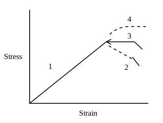
किसी शैल के लिए गए प्रतिबल–विकृति ग्राफ में खण्ड 2 निरूपित करता है :
- AElastic deformationप्रत्यास्थ विरुपण
- BPlastic deformationसुघटय विरुपण
- CStrain hardeningविकृति दृढ़ीकरण
- DStrain softeningविकृति मृदुलन
Show answer
Concept: After the elastic straight line (1) and the yield point, the curve can follow three paths: horizontal (3) = ideal plastic flow, rising (4) = strain hardening (more stress needed for more strain), falling (2) = strain softening (stress needed drops as strain increases).
- Sector 2 slopes downward beyond yield – the rock weakens with continued strain → strain softening.
- Sector 1 – elastic; sector 3 – perfectly plastic; sector 4 – strain hardening.
Short trick: After yield: up = hardening, flat = plastic, down = softening.
अवधारणा: प्रत्यास्थ सीधी रेखा (1) व पराभव बिंदु के बाद वक्र तीन मार्ग ले सकता है: क्षैतिज (3) = आदर्श सुघट्य प्रवाह, ऊपर उठता (4) = विकृति दृढ़ीकरण, नीचे गिरता (2) = विकृति मृदुलन।
- खंड 2 पराभव के बाद नीचे झुकता है – विकृति बढ़ने पर शैल कमजोर होता है → विकृति मृदुलन।
- खंड 1 – प्रत्यास्थ; 3 – पूर्ण सुघट्य; 4 – विकृति दृढ़ीकरण।
याद रखें: पराभव के बाद: ऊपर = दृढ़ीकरण, सपाट = सुघट्य, नीचे = मृदुलन।
UPHESC Assistant Professor GeologyGeology / Earth SciencesStress–strain behaviour of rocksUPHESC Assistant Professor Geology · Booklet 1C78 (Series A)
Q95.In northern hemisphere oceanic circulation happens :
उत्तरी हेमिस्फीयर में समुद्र का सरकुलेशन किस तरीके का होता है :
- AAnti clockwiseएन्टीक्लाकवाइज
- BClockwiseक्लाक वाइज
- CParallel to equatorइक्वेटर के समानन्तर
- DParallel to poleपोल के समानान्तर
Show answer
Concept: Driven by the trade winds and westerlies and deflected to the right by the Coriolis force, the major subtropical ocean gyres circulate clockwise in the Northern Hemisphere and anticlockwise in the Southern Hemisphere.
- N. Atlantic gyre: Gulf Stream → N. Atlantic Drift → Canary → N. Equatorial current (clockwise).
- N. Pacific: Kuroshio → N. Pacific → California → N. Equatorial (clockwise).
Short trick: North – Coriolis to the right – clockwise gyres.
अवधारणा: व्यापारिक पवनों व पछुआ पवनों से संचालित तथा कोरिऑलिस बल से दाईं ओर विक्षेपित होकर, उत्तरी गोलार्ध में प्रमुख उपोष्ण महासागरीय भँवर दक्षिणावर्त (क्लॉकवाइज़) और दक्षिणी गोलार्ध में वामावर्त घूमते हैं।
- उत्तरी अटलांटिक: गल्फ स्ट्रीम → उ. अटलांटिक ड्रिफ्ट → कैनरी → उ. विषुवतीय धारा।
- उत्तरी प्रशांत: क्यूरोशियो → उ. प्रशांत → कैलिफ़ोर्निया धारा।
याद रखें: उत्तर – कोरिऑलिस दाईं ओर – दक्षिणावर्त।
UPHESC Assistant Professor GeologyGeology / Earth SciencesOcean gyresUPHESC Assistant Professor Geology · Booklet 1C78 (Series A)
Q96.The largest highest and most extensive reefs of all type of coral reefs :
सभी प्रकार की मूंगे की भितियों में विशालतम उच्चतम और सबसे लायक भिति है :
- ABarrier reefsवैरियर भितियाँ
- BAtollsप्रवाल द्वीप
- CFringing reefsसजावटी भितियाँ
- DLagoon reefsलैगून भितियाँ
Show answer
Concept: Barrier reefs, separated from the coast by a wide, deep lagoon, are the largest, highest and most extensive of all reef types; the Great Barrier Reef of Australia extends ~2300 km.
- Fringing reefs – narrow reefs attached to the shore; most common but small.
- Atolls – ring-shaped reefs around a lagoon, no central island (e.g. Lakshadweep).
Short trick: Great Barrier Reef = the biggest reef = barrier type.
अवधारणा: अवरोधक (बैरियर) भित्तियाँ, जो तट से चौड़े-गहरे लैगून द्वारा अलग होती हैं, सभी प्रकारों में सबसे बड़ी, ऊँची और विस्तृत होती हैं; ऑस्ट्रेलिया की ग्रेट बैरियर रीफ ~2300 किमी लंबी है।
- तटीय (फ्रिंजिंग) भित्ति – तट से जुड़ी संकरी भित्ति।
- एटॉल – लैगून को घेरती वलयाकार भित्ति (लक्षद्वीप)।
याद रखें: ग्रेट बैरियर रीफ = सबसे बड़ी = अवरोधक भित्ति।
UPHESC Assistant Professor GeologyGeology / Earth SciencesCoral reefsUPHESC Assistant Professor Geology · Booklet 1C78 (Series A)
Q97.Thermohaline circulation is related to which of the following ?
थरमोहेलाइन परिसरचण निम्न में से किससे सम्बन्धित है ?
- ATemperature gradient in mantleमेन्टल के तापमान प्रवणता
- BSurface currents in oceanसमुद्र में सतहीय प्रवाह
- CDifference in salinity and temperature of oceanic waterसमुद्रीय जल की लवणता एवं तापमान के अन्तर
- DConvection currents in troposphereट्रोपोस्फीयर में कन्वेक्शन करेन्ट
Show answer
Concept: Thermohaline ('thermo' = heat, 'haline' = salt) circulation is the global deep-ocean 'conveyor belt' driven by density differences caused by temperature and salinity.
- Cold, salty water sinks in the North Atlantic and around Antarctica, flows along the deep ocean and upwells elsewhere.
- Surface currents are mainly wind-driven, not thermohaline.
Short trick: Thermo + haline = temperature + salt → density-driven deep currents.
अवधारणा: तापलवणीय (थर्मो = ताप, हेलाइन = लवण) परिसंचरण ताप व लवणता से उत्पन्न घनत्व-अंतर से चलने वाला वैश्विक गहन महासागरीय 'कन्वेयर बेल्ट' है।
- ठंडा, खारा जल उत्तरी अटलांटिक व अंटार्कटिका के पास डूबता है और गहराई में बहकर अन्यत्र ऊपर आता है।
- सतही धाराएँ मुख्यतः पवन-चालित हैं।
याद रखें: थर्मो + हेलाइन = ताप + लवण → घनत्व-चालित गहन धाराएँ।
UPHESC Assistant Professor GeologyGeology / Earth SciencesThermohaline circulationUPHESC Assistant Professor Geology · Booklet 1C78 (Series A)
Q98.What is the rate of terrigenous sediment accumulation on the deep ocean floor ?
डीप समुद्र सतह पर टेरीजीनस सेडीमेंट संचय होने की दर क्या होती है ?
- A2 mm/year
- B2 mm/100 year
- C3.1 mm/year
- D2 mm/1000 year
Show answer
Concept: Fine terrigenous (wind- and current-borne) clay settles on the abyssal floor extremely slowly – of the order of 1–2 mm per 1000 years (pelagic red/brown clay).
- Biogenic oozes accumulate faster, ~1–3 cm/1000 yr.
- mm/year rates are typical of continental shelves, deltas and lakes – far too fast for the deep ocean.
Short trick: Deep-sea clay: about a millimetre per millennium.
अवधारणा: महीन स्थलजात (पवन व धारा-वाहित) क्ले गहन सागर तल पर अत्यंत धीरे जमती है – लगभग 1–2 मिमी प्रति 1000 वर्ष (पेलैजिक लाल/भूरी क्ले)।
- जैवजनित ऊज़ इससे तेज़, ~1–3 सेमी/1000 वर्ष।
- मिमी/वर्ष दर महाद्वीपीय शेल्फ, डेल्टा व झीलों की होती है।
याद रखें: गहन सागर क्ले: लगभग 1 मिमी प्रति सहस्राब्दी।
UPHESC Assistant Professor GeologyGeology / Earth SciencesDeep-sea sedimentation ratesUPHESC Assistant Professor Geology · Booklet 1C78 (Series A)
Q99.Which ooze in the most common found on the ocean floor around the Antarctica ?
अंटार्कटिका के चारों तरफ समुद्र सतह पर कौन सा ऊज सामान्य तौर पर मिलता है :
- ARadiolarean oozeरेडियोलेरियन ऊज
- BDiatom oozeडाइएटम ऊज
- CCarbonate oozeकारबोनेट ऊज
- DAll of the aboveउपरोक्त सभी
Show answer
Concept: A broad belt of siliceous diatom ooze encircles Antarctica (Southern Ocean) and also occurs in the high-latitude North Pacific, where cold, nutrient-rich upwelling waters support diatom blooms.
- Radiolarian ooze – mainly the equatorial Pacific.
- Carbonate (Globigerina) ooze – warm, shallower (above CCD) floors of the Atlantic; carbonate dissolves in cold Antarctic waters.
Short trick: Diatoms – cold poles; Radiolaria – equator; Globigerina – warm, above CCD.
अवधारणा: अंटार्कटिका (दक्षिणी महासागर) के चारों ओर सिलिकामय डायटम ऊज़ की चौड़ी पट्टी है (उत्तरी प्रशांत के उच्च अक्षांशों में भी), जहाँ ठंडा, पोषक-समृद्ध उत्प्रवाह डायटम को बढ़ाता है।
- रेडियोलेरियन ऊज़ – मुख्यतः विषुवतीय प्रशांत।
- कार्बोनेट (ग्लोबिजेराइना) ऊज़ – गर्म, CCD से ऊपर के तल; ठंडे जल में कार्बोनेट घुल जाता है।
याद रखें: डायटम – ठंडे ध्रुव; रेडियोलेरिया – विषुवत; ग्लोबिजेराइना – गर्म।
UPHESC Assistant Professor GeologyGeology / Earth SciencesPelagic oozes – distributionUPHESC Assistant Professor Geology · Booklet 1C78 (Series A)
Q100.In an area, where piezometric surface overlies the ground surface, which one of the following well types will result ?
किसी क्षेत्र में पीजोमेट्रीक तल यदि सतही तल के उपर पाया जाता है तो इनमें से किस तरह के वेल (कुंए well) पाये जायेगें ?
- AOrdinary wellसामान्य वेल (कुंए)
- BDry wellसुखे हुए कुंए
- CFlowing wellबहता हुआ वेल (कुंआ)
- DNone of theseइनमें से कोई नहीं
Show answer
Concept: In a confined aquifer, water in a well rises to the piezometric (potentiometric) surface; where this surface lies above ground level, water flows out at the surface without pumping – a flowing artesian well.
- If the piezometric surface is above the aquifer top but below ground → non-flowing artesian well.
- Classic example: Great Artesian Basin, Australia.
Short trick: Piezometric surface above ground = free-flowing artesian well.
अवधारणा: परिरुद्ध जलभृत में कुएँ का जल दाब-मितीय (पीज़ोमेट्रिक) तल तक उठता है; जहाँ यह तल भूमि सतह से ऊपर हो, वहाँ बिना पम्प के जल अपने आप बाहर बहता है – प्रवाही आर्टिज़ियन कुआँ।
- यदि पीज़ोमेट्रिक तल जलभृत से ऊपर पर सतह से नीचे हो → अप्रवाही आर्टिज़ियन कुआँ।
- उदाहरण: ऑस्ट्रेलिया का ग्रेट आर्टिज़ियन बेसिन।
याद रखें: पीज़ोमेट्रिक तल सतह से ऊपर = स्वतः बहता कुआँ।
UPHESC Assistant Professor GeologyGeology / Earth SciencesArtesian (flowing) wellsUPHESC Assistant Professor Geology · Booklet 1C78 (Series A)

